


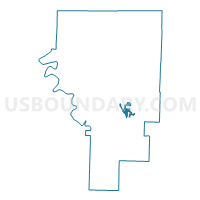
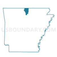
Voting District 11-1, Baxter County, Arkansas
About
Outline

Summary
| Unique Area Identifier | 525893 |
| Name | Voting District 11-1 |
| County | Baxter County |
| State | Arkansas |
| Area (square miles) | 2.21 |
| Land Area (square miles) | 2.02 |
| Water Area (square miles) | 0.19 |
| % of Land Area | 91.24 |
| % of Water Area | 8.76 |
| Latitude of the Internal Point | 36.20892990 |
| Longtitude of the Internal Point | -92.27562340 |
Maps

Graphs
Select a template below for downloading or customizing gragh for Voting District 11-1, Baxter County, Arkansas


Neighbors
Neighoring Voting District (by Name) Neighboring Voting District on the Map
- Voting District 11-3, Baxter County, AR
- Voting District 11-4, Baxter County, AR
- Voting District 9-5, Baxter County, AR
Top 10 Neighboring County Subdivision (by Population) Neighboring County Subdivision on the Map
- North Fork township, Baxter County, AR (1,574)
- Buckhorn township, Baxter County, AR (969)
- Lone Rock township, Baxter County, AR (415)